3.4.1. Band set
 Band set
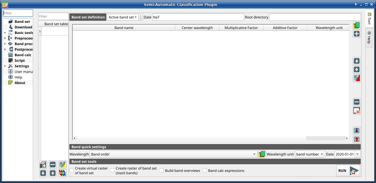
Image input in SCP is named band set. This tab allows for the definition of one or multiple band sets to be used as input for classification and other tools.
Band sets are identified by numbers. The active band set (i.e. the one selected in Band set definition) is used as input for several tools in SCP dock and the Working toolbar. Other SCP tools allow for the selection of band set numbers.
The Band set definition is saved with the QGIS project.
Порада
Information about APIs of this tool in Remotior Sensus at this link .
Following a video tutorial about this tool.
https://www.youtube.com/watch?v=DQXfBPke2J4
3.4.1.1. Band set definition
A band set is basically a list of bands defined as the following table.
Band name |
Center wavelength |
Multiplicative Factor |
Additive Factor |
Wavelength unit |
Path |
Date |
|---|---|---|---|---|---|---|
name of the band (it cannot be edited) |
center of the wavelength of the band |
multiplicative rescaling factor |
additive rescaling factor |
wavelength unit |
relative path of the raster |
image acquisition date |
It is possible to add to the active band set one or more bands already loaded in QGIS, or select files that are not loaded. A Date can be assigned to a band set which can be later used in other tools to select band sets by date. Also, a Root directory for band paths can be defined, which can be useful to create projects with relative paths.
The following tools are available.
Tool symbol and name |
Description |
|---|---|
|
open file explorer and add raster files (preferably single band raster) to the active band set |
|
open a window to select rasters already loaded in QGIS and add them to the active band set |
|
move highlighted bands upward |
|
move highlighted bands downward |
|
sort automatically bands by name, giving priority to the ending numbers of name |
|
remove highlighted bands from the active band set |
|
clear all bands from active band set |
|
import a previously saved active band set from file |
|
export the active band set to a file |


It is possible to define a multiplicative rescaling factor and additive
rescaling factor for each band (for instance using the values in
Landsat metadata), which are used on the fly
(i.e. pixel value = original pixel value * multiplicative rescaling factor + additive rescaling factor)
during the processing.
The Center wavelength of bands should be defined in order to use several functions of SCP. If the Center wavelength of bands is not defined, the band number is used and some SCP tools will be disabled.
3.4.1.2. Band quick settings
These tools allow for quickly set attributes of the active band set.
Tool symbol and name |
Description |
|---|---|
Wavelength |
rapid definition of band center wavelength for the following satellite sensors: * Band order * ASTER * GeoEye-1 * GOES * Landsat 8 OLI * Landsat 7 ETM+ * Landsat 4-5 TM * Landsat 1, 2, and 3 MSS * MODIS * Pleiades * QuickBird * RapidEye * Sentinel-2 * Sentinel-3 * SPOT 4, 5, and 6 * WorldView-2 and WorldView-3 |
|
open a csv file of wavelength values (center wavelength separated by comma or new line) |
Wavelength unit |
|
Date |
set the date of acquisition |


3.4.1.3. Band set table
The table on the left side is the Band set table. It includes the list of all the defined band sets (the names of the first bands are displayed), which can be selected with a left click. Double click on a table item can be used to define the Active band set.
A Filter can be used to display band sets in the table matching a name.
The following tools are available for managing band sets.
Tool symbol and name |
Description |
|---|---|
|
add a new empty band set |
|
remove highlighted band sets |
|
sort band sets by date |
|
move highlighted band sets upward |
|
move highlighted band sets downward |
|
display the RGB color composite of selected band sets (a virtual raster is added in QGIS) |


3.4.1.4. Band set tools
Band set tools are tools that can be executed directly on Active band set. Multiple tools can be selected by the corresponding check box. This can also be useful to automate the processing during image conversion.
Tool symbol and name |
Description |
|---|---|
|
create a multiband virtual raster of Active band set |
|
stack bands in a single multiband raster |
|
build band overview of Active band set |
|
execute the expression defined in Band calc |
|
execute selected tools |

